|
|
|
| Reference Series |
Table of Contents For This Issue
|
|
| |
| How Computers Work, Part I | |
|
August 2001• Vol.5 Issue 3 Page(s) 138-143 in print issue | |
GPS Offers More Than A Bird’s-Eye View Simple Geometry & High Technology Help The Global Positioning System Find Your Place On Earth |
|
To know where you are on Earth, it helps to have a connection in space. The GPS (Global Positioning System), a network of 24 satellites that orbits every 12 hours some 11,000 miles above the planet, presents the
ultimate answer to the problem of determining location. Dramatically more accurate than any other method ever devised, GPS and its variations are capable
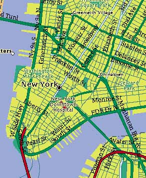
of fixing the latitude, longitude, altitude, and velocity of a user anywhere in the world to within mere centimeters. The GPS concept definitely relies on high technology for its implementation (after all, putting anything up in space takes some rocket science) but the underlying ideas that make GPS tick come straight out of the sixth grade. If you can follow a little geometry, you can understand the clever simplicity of GPS. For instance, Bob knows he is exactly 100 miles from the Empire State Building in New York City. That narrows down his location quite a bit. In all of creation, Bob must be somewhere on a sphere that is defined by all points 100 miles from the building. Of course, some of these geometric points don’t make sense; Bob isn’t likely to be 100 miles directly below the building. Assuming he’s on terra firma, the 100-mile radius circle formed where the sphere intersects the ground still leaves a lot of space to wander around. Next, we’ll add another bit of information. Bob also knows he is 150 miles from the Washington Monument. If we picture these two spheres (the first around the Empire State Building in New York City and the second around the Washington Monument in Washington D.C.), we can imagine that where the spheres intersect would be a vertical circle starting in the Atlantic Ocean, arching over New Jersey, and then diving underground in Pennsylvania. We know Bob is at the edge of each of these spheres simultaneously, so he must be somewhere on that vertical circle where they meet. If Bob is on the ground, there are only two places he could be, where the circle hits the ocean and the land. Then again, if he is in an airplane or submarine, we’re going to need more information to narrow down his position. We need more spheres. Fortunately, Bob also knows his distance from both Mount Rushmore and Winslow, Ariz. These four spheres, each with a radius measured in miles to Bob, come together at only one point in the entire universe. A computer can quickly figure out at which latitude, longitude, and altitude that point lies. We’ve found Bob’s location based not on anything near him, but only on accurate measurements of distances between him and points far away. This technique is commonly known as triangulation, a name based on the fact that locating a point in two-dimensional space, such as a sheet of paper, requires only three reference points. Finding someone in a three-dimensional universe, such as our example with Bob, takes four reference points, but the concept is the same.
This is where GPS really starts to show off its cleverness. Each GPS satellite beams out a particular radio signal. Like all radio signals, the GPS transmissions move through space to Bob at the speed of light, a constant that clocks in at about 186,000 miles per second. If we know exactly when the signal starts and when it gets to Bob, we can calculate the distance between the two points. The math works exactly like those story problems we all remember from school. If locomotive A leaves the station at noon, travels at 100 miles per hour, and reaches station B at 1 p.m., we know A and B must be 100 miles apart. In other words, distance traveled equals time multiplied by speed. A GPS signal that takes one-sixteenth of a second to reach you must have traveled about 11,625 miles. GPS ground receivers don’t actually click a stopwatch when a satellite begins transmitting. For one thing, there would be no way to know when the satellite started. Instead, both the satellites and receivers continuously emit a signal called Pseudo Random Code that repeats at precise times. As its name suggests, Pseudo Random Code is a fairly complex signal that would sound like fuzz to people. Given a few moments, however, receivers can pick out the codes from the general background noise. The receiver then compares the satellite’s code to its own. If the satellite and the receiver were right next to each other, the codes would be in step together. However, as the satellite moves farther from the receiver, its code falls behind because of the distance it has to travel. Measuring how far out of sync the two codes are tells the receiver the distance to the satellite. Gauging how long trains take to reach a station is one thing, but figuring these split-second, light-speed differences takes more than your average Timex. The device that makes GPS possible is the atomic clock, which measures time by tracking the oscillations of a certain type of atom. Atomic clocks are fantastically accurate; they are accurate enough to do the job we need it to do over and over again without rewinding. Each GPS satellite carries an atomic clock with it as it orbits the Earth. Sounds handy, but unfortunately, an atomic clock up in space doesn’t do much for Bob and his handheld GPS receiver. He needs the accurate timepiece on his end to measure all of these signals, but atomic clocks (which can vary greatly in price) may be a bit out of Bob’s price range. Or maybe he hasn’t been able to get his hands on one of the more affordable atomic clocks or atomic wristwatchs available today. Whatever the case may be, once again, we need to turn to our old friend geometry. Say we have incoming signals from four satellites but an inaccurate clock in our receiver that adds one second to the actual time. The spheres we draw based on measurements from this slow clock won’t meet at one particular point as we expect. However, we do know the timing error was the same for all of the measurements. As a result, the GPS receiver will automatically try adding or subtracting the same number of seconds to all the values at once until it finds a combination where the spheres meet at a single point, as they should. When it finds the right value, the receiver resets its own internal, less-accurate clock back a second, so it will once again be in sync with the atomic clocks in space. Notice that not only does this give Bob his exact position but it also turns his rather standard clock into a superaccurate clock that continuously resets itself to the true time. Bob will never be late again. Another advantage to this system is that Bob can figure out how fast he is going. If you know your exact position at various exact times, velocity is easy. With its atomic clocks, the GPS system so accurately measures velocity that it has been used to determine where the Earth’s tectonic plates are moving and how fast. For instance, most of Los Angeles is moving to the southeast at around 2 centimeters per year. See the GPS Time Series Web site (http://sideshow.jpl.nasa.gov/mbh/series.html) for more interesting measurements. The high-altitude orbits used by the GPS are stable enough that it is mathematically possible to figure out the exact location of any satellite in advance given known coordinates and velocity at some point in the past. GPS receivers carry with them this knowledge that is based on simple laws of gravity. However, tiny errors can creep in. The moon and other astronomical bodies exert miniscule gravitational forces on the satellites, as does the constant stream of particles, known as the solar wind, flying away from the sun. Fortunately, the effect is small, but the highly accurate results of GPS rely on highly accurate measurements every step of the way. To make sure the satellites are exactly where they’re supposed to be, the military monitors them with radar at five ground stations (whose positions are already accurately known) around the world. If a satellite is slightly out of the predicted path, this information is uploaded to the satellite itself. The correction is then incorporated into the data the satellite sends streaming to Earth. Thus, the GPS receiver picks up not only the timing code but also special information that tells it what, if any, corrections it needs to factor into the equation. Finally, we have what we need to find Bob. We know the location of the satellite with corrections; the time it takes for the GPS signal to reach Bob’s receiver, thanks to its continuously updated clock; and we have our high school math formulas. The rest is just a matter of locating the signals from enough satellites and plugging in the data. GPS isn’t something you could cook up in your backyard with a hammer and a video from your local home-improvement store, but the basic ideas aren’t hard to grasp. Selective Availability introduces what can amount to a 100-meter error on the ground. That’s still accurate enough for something such as figuring out where you are in an unfamiliar city, but it won’t tell you on which side of the street you are. Fortunately for everyone not privy to military technology, there’s a simple solution that makes the government’s attempt to keep accurate GPS all to itself almost laughable. Differential GPS, or DGPS, adds an extra signal to the mix; this signal is broadcast by a ground station whose location is precisely known. The ground station simply compares where GPS says it is to the station’s actual location, figures out the difference between the two, and broadcasts the information to all other GPS receivers. The Selective Availability error is wiped out, although it takes a special, more expensive DGPS receiver to do it. Actually, it gets even better. Because all of the errors (Selective Availability, atmospheric conditions, and everything else) will be the same for all GPS receivers in the same general vicinity, DGPS can factor out almost all errors. The result is accuracy even better than standard military-grade GPS. Private companies, such as oil prospectors and others who rely heavily on GPS, often set up local-area DGPS stations to get the best readings possible. Extremely expensive systems based on this principle are so accurate they can be less than a centimeter off. Most of us can’t afford to build and maintain our own network of DGPS ground stations, but fortunately the U.S. Coast Guard makes the signals from its system available for free. That’s right, the same government that introduces error into the GPS system hands out a workaround in many areas at no cost. A few years back, perhaps with this fact in mind, the military announced that Selective Availability would be phased out in upcoming years. DGPS will still be required for the most accurate readings because of natural errors, but the end of Selective Availability should make cheaper, non-DGPS receivers substantially better. GPS technology represents at least a small return on a generation’s worth of tax money. Like the Internet, GPS is an open standard with incredible commercial potential that actually began in military secrecy during the paranoia of the Cold War.
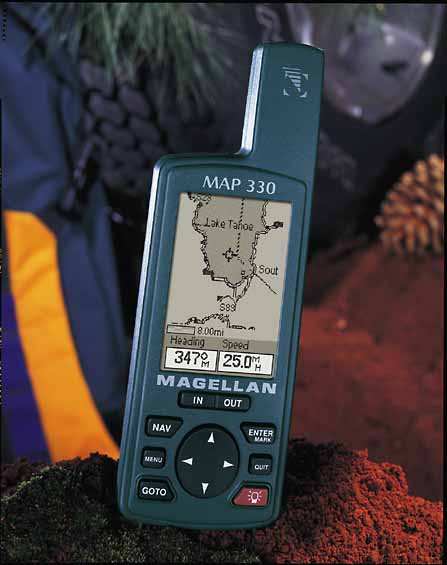
The military began launching its $12 billion constellation of 24 GPS satellites in 1978. The most recent satellite was put in orbit on Jan. 30. In the meantime, the usefulness of a system that allowed relatively small earth-bound receivers to instantly determine accurate latitude and longitude became apparent to many others in the armed services and, increasingly, in the commercial sphere. For now, the military keeps the most accurate signal for itself in order to prevent enemies from using GPS against its creators. However, the civilian market has found ways around the introduced errors. Today, GPS can be found in a growing variety of interesting applications, both within and outside the military. GPS receivers, combined with special radio transmitters, allow downed pilots to secretly call in their positions behind enemy lines. Commercial jetliners incorporate differential GPS receivers that let the airplane’s computer system know where the aircraft is with enough accuracy to land the plane automatically. Surveying teams make use of accurate GPS receivers to mark locations of land boundaries, utility lines, streets, and other features. Orbiting satellites include special GPS receivers made to compute location at high velocities. Some users, such as astronomers, rely on GPS receivers not for location, but for their superaccurate timing ability. Serious backpackers may pick up a handheld receiver to tell them their latitude and longitude when they are far from civilization. The biggest potential for GPS is yet to be realized, but GPS is showing up in many different places. GPS receivers are starting to appear in newer automobiles and include a small screen with the driver’s current location plotted on a local street map. Companies and cities that own many vehicles are starting to use GPS to keep track of entire fleets. Proponents of the technology foresee a day when tiny receivers can be mounted almost anywhere to locate almost anything, from toddlers to trucks. Today’s consumer-oriented GPS devices come in a few different styles. The most basic handheld receivers look like a walkie-talkie but feature a small LCD screen. The readout provides you with information such as your current latitude and longitude, accurate time, heading, and velocity. These devices will usually show a graphical representation of your route with user-definable waypoints so you can find your way back or track your progress to a spot up ahead. Handheld GPS receivers weigh roughly 10 ounces and run on standard batteries. A good basic receiver like this, such as the Garmin GPS 12 (http://www.garmin.com), costs about $150. Most of the GPS receivers on the market, from relatively cheap on up, can be connected to a DGPS receiver for the ultimate in accuracy. Alone, a typical receiver still boasts the capability for accuracy to within 30 meters anywhere in the world, although the military-imposed Selective Availability today limits that to 100-meter accuracy. What the lower-priced units lack are maps. If you want a screen that not only shows you your coordinates but also plots them on a digital representation of the vicinity, you’ll have to cough up a little more money. Units that feature basic maps with major roads, coastlines, lakes, and rivers usually cost $300 or more. The Garmin StreetPilot includes major roads throughout most metropolitan areas and accepts optional plug-in cards that fill in the rest of the streets for different regions. Designed to be easily mounted on a dashboard, the StreetPilot in the neighborhood of $550. For the avid travelers there’s the Magellan (http://www.magellangps.com) Map 330. The Map 330 gives users the ability to view navigation information on any of its four graphic screens. It has a built-in 8MB base map that pinpoints U.S. cities, major roadways, highways, national parks, airports, railways, and waterways and more. Optional software lets users access detailed information to help with their navigational needs. For automobile use, cheaper GPS receivers without screens or buttons of their own plug into laptop PC Card slots. By attaching the power of a laptop, lower-end GPS receivers gain some mapping features you still can’t find in the most expensive models. DeLorme’s $150 Earthmate, for instance (http://www.delorme.com), plots your position on a continuously updated street-level map of the entire United States that is stored on a CD-ROM. The software helps keep track of travel plans and, through the computer’s speakers, gives you verbal directions to guide you to a destination. The drawback, of course, is you have more to haul around. For the business traveler with an empty passenger seat, it’s not so bad to have an open laptop sitting around. For the backwoods camper, anything more than a handheld unit gets cumbersome. The genius of GPS is that every component is designed to relieve the client hardware (the GPS receiver) of any heavy lifting. There’s no need to carry around an atomic clock, a huge antenna, a complicated computer, or a transmitter. Everything is contained either on the GPS satellites or at numerous ground stations. That means the receivers can be built small, lean, and portable enough to be taken into the field anywhere. This, the most important feature of GPS, is what makes it so powerful. On land or sea or in the air, the unparalleled accuracy of the world’s best locator can be carried in the palm of your hand. Thanks to a group of machines whizzing by more than 10,000 miles up in space, you can know exactly where on Earth you stand. by Alan Phelps View the graphics that accompany this article. Up In The Sky How The Global Positioning System Works (NOTE: These pages are PDF (Portable Document Format) files. You will need Adobe Acrobat Reader to view these pages. Download Adobe Acrobat Reader)
|